The K&P Trail is a 180-km multi-use recreational rail trail that connects downtown Kingston to the Town of Renfrew where it intersects with the Ottawa Valley Recreational Trail. Frontenac County owns and operates the 90 km stretch referred to as the “Frontenac K&P Trail” from KM 21 where the City of Kingston borders with the Township of South Frontenac, to KM 98 near Snow Road Station. The County plans to continue redevelopment of the former railway an additional 12 kilometres from Clarendon Station to the municipal border shared with Lanark County. The trail continues North to Calabogie and Renfrew from that boundary.
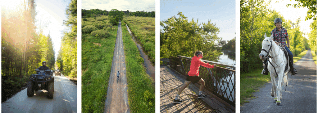
In Frontenac County, the K&P Trail is a fully developed stone dust rail-trail with stops in the communities of Sharbot Lake, Godfrey, Verona, and Harrowsmith along the way. The trail support year-round recreational activities such as cycling, walking, hiking, horseback riding, ATV use*, and snowmobiling. The trail intersects with the Tay-Havelock Trail in Central Frontenac and the Cataraqui Trail in South Frontenac, and together the three trails form the Trans Canada Trail route through Frontenac County.
Permitted Activities
The Frontenac K&P Trail (located within Frontenac County) is a multi-use trail, shared by pedestrians, equestrians, cyclists (including e-bikes) and motorized users on a year-round basis. The trail is open for use between 6:00 a.m. and 10:00 p.m. from April 1 to November 30 and between 7:00 a.m. and 10:00 p.m. from December 1 to March 30 of any given year. Camping is not permitted along the K&P Trail. Hunting from the K&P Trail is strictly prohibited. For a full set of regulations, please review Frontenac County Bylaw No. 2022-033.
Motorized Use:
ATV, Side-by-Side and OHRV:
- Seasonal permits are required for motorized access to the permitted section of the K&P Trail. Permits are included in the annual membership dues of the Frontenac ATV Club (An OFATV affiliate) or the Eastern Ontario Trails Alliance (EOTA). Memberships are $150 (2025) and can be had after the links above.
- The K&P Trail is open for ATV use from early April (depending on the spring thaw) to November 30 each year. ATV operators are encouraged to avoid use of the K&P during the spring thaw to limit potential surface damage.
- ATV users may access the K&P Trail at any location north of Bellrock Road, unless otherwise posted. Access is not granted for ATV’s to use the K&P Trail South of Bellrock Road.
Snowmobiles:
- Snowmobile use is permitted on the entire Frontenac K&P Trail from Orser Road to Clarendon Station between December 1 and and March 31 each winter season AND are only permitted on the K&P Trail once it has been groomed and marked available on the Ontario Federation of Snowmobile Clubs interactive map.
- The K&P Trail is an Ontario Federation of Snowmobile Clubs Prescribed Trail and all snowmobiles must follow the regulations outlined in the Motorized Snow Vehicle Act 1990, R.S.O.
- During this period, local snowmobile clubs assume responsibility for the management and grooming of trails for snowmobile use, sale of trail passes, and regular patrols of the trail.
Resources
- The K&P Trail Information Hub provides updates on various projects and events
- Frontenac K&P Trail Management Plan (2021)
- Take a virtual tour of the Frontenac K&P Trail
- Join the Frontenac K&P Trail conversation online:
- By-Law No. 2022-0033 A By-Law to Regulate and Govern the Use of the Frontenac K&P Trail (Currently being updated to include clauses associated with the requirement for motorized users to have a pass or permit with an authorized partner as directed by County Council at its regular meeting on February 19, 2024)
Trail Maps
- KM 21 to KM 32: Orser Road to Harrowsmith
- KM 32 to KM 40: Harrowsmith to Verona
- KM 40 to KM 52: Verona to Hinchinbrooke Station
- KM 52 to KM 63: Hinchinbrooke Station to Tichborne
- KM 63 to KM 77: Tichborne to Sharbot Lake
- KM 77 to KM 90: Sharbot Lake to Clarendon Station
Full maps package (KM 0 – KM 90)
Additional documents are available upon request by completing a document request form. If you require in accessible format please let us know.